Knoll E12 remote bush camp
Surrounded by dense subtropical rainforest, this camp site is an old survey point and is popular as a layover on longer walks in the park.
Accessible by
- Walk-in
Camping area facilities
- Tent camping
- Long walk to tent
- Walking
-
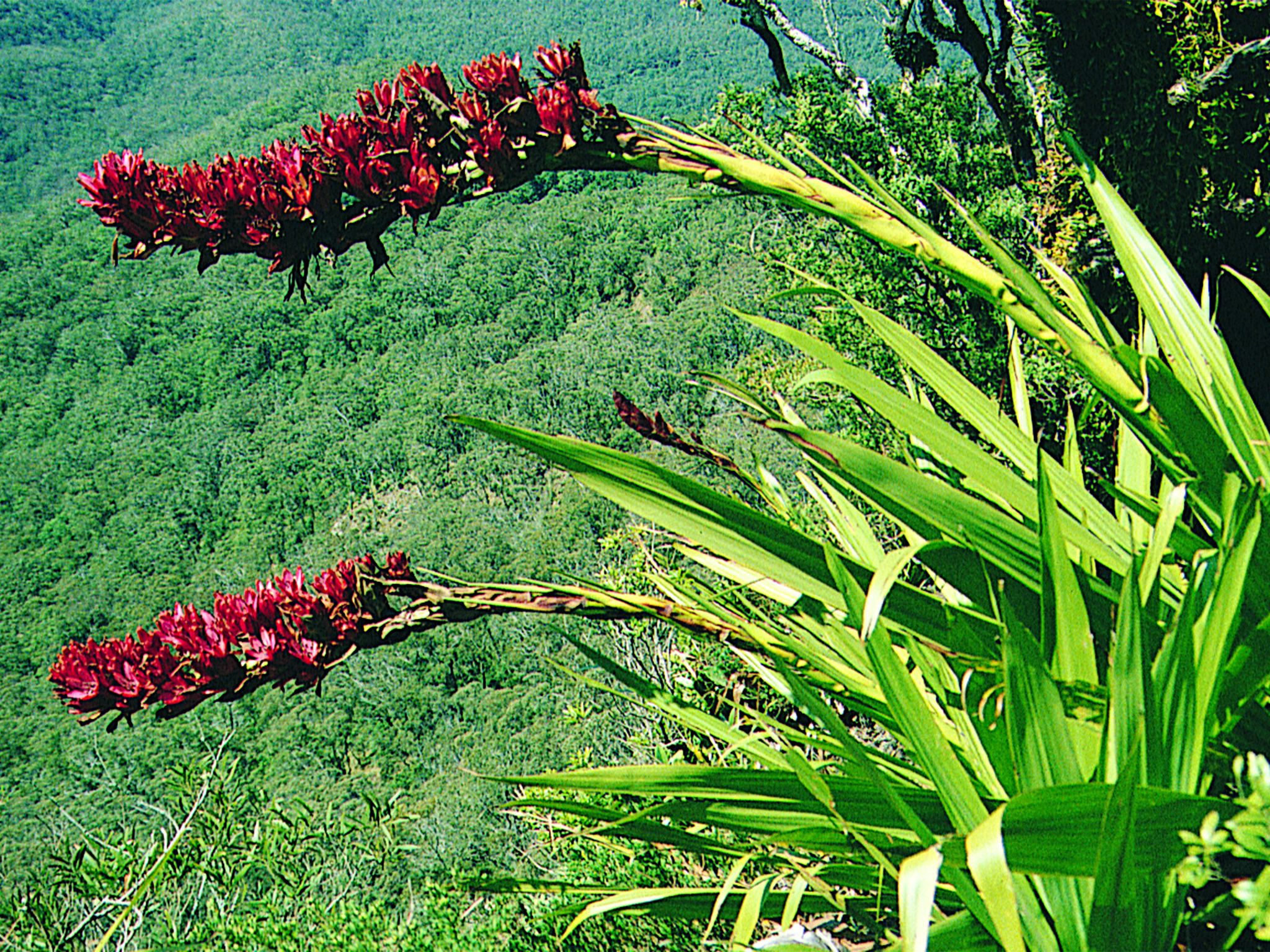
![Look for giant spear lilies at the nearby lookout.]() Look for giant spear lilies at the nearby lookout.
Photo credit: Robert Ashdown © Queensland Government
Look for giant spear lilies at the nearby lookout.
Photo credit: Robert Ashdown © Queensland Government
-
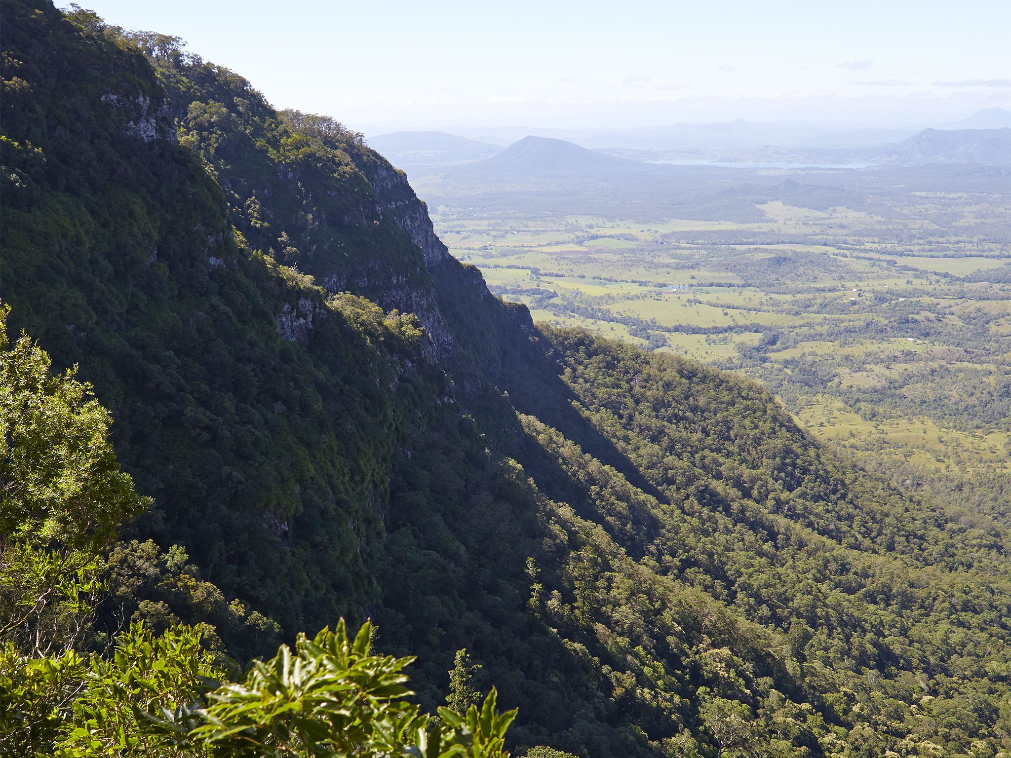
![Nearby Sylvesters lookout has magnificent views.]() Nearby Sylvesters lookout has magnificent views.
Photo credit: Maxime Coquard © Queensland Government
Nearby Sylvesters lookout has magnificent views.
Photo credit: Maxime Coquard © Queensland Government
Always check
- Park alerts for the latest information on access, closures and conditions.
- Bureau of Meteorology weather forecasts.
- Current bushfire warnings and incidents and also fire bans and restrictions.
- Your camping permit is booked.
- Any park-specific camping information for
Main Range.
- Visiting Main Range safely for important safety information.
If you’re an experienced off-track walker with specialist equipment and well-developed navigational skills, then the walk to this remote camp site is for you.
After you’ve set up camp, head to nearby Sylvesters lookout for impressive views over the coastal plains below, including the southern reaches of Lake Moogerah and the rugged Border Ranges to the south. Look for the magnificent hanging gardens of giant spear lilies gripping the exposed rocky outcrops and sheer cliff lines.
Narrow-leaved orange thorn shrubs edge the camp site. During September and October the air is heavy with the sweet-smelling fragrance of their yellow-green flowers, which are followed by vivid purple berries (that you can’t eat!).
This park is part of the Gondwana Rainforests of Australia World Heritage Area, famed for its ongoing geological processes, evolutionary history, and diversity (especially of rare, threatened and endemic species).
Getting there and getting around
Knoll E12 remote area bush camp is in Main Range National Park, about 120km south-west of Brisbane.
Before preparing to walk to remote camping areas, walkers should consider their experience and preparedness levels. A high level of physical fitness and navigational skills are essential.
- Plan to walk safely and be responsible.
- Familiarise yourself with the area before attempting an extended walk.
- Check park alerts for the latest information on access, closures and conditions.
- Research the route thoroughly and get local advice. Recommended maps for bushwalking are 1:25,000 topographic maps. It is also advisable to carry a recognised guidebook for the area.
- Carry good navigation and communication gear.
- Complete a bushwalking advice form and leave your plan with a responsible person.
- Contact your local walking club or Bushwalking Queensland for further information.
Camping permits are essential.
Before you visit
Opening hours
Knoll E12 remote area bush camp is open 24 hours a day. Check-in to your camp after 2pm and check-out by 11am on the day of departure.
Check park alerts for the latest information on access, closures and conditions.
Camping area features: Rainforest site primarily used as a stopover on longer walks. No views.
Location: Map Sheet: Townson 9342-22. Grid Reference: 393 047. GPS Reference: TBA.
Access: Nearest vehicle access is via Lookout Road from the Goomburra camping area to Sylvesters Lookout walking track. Access is by high clearance 2WD in dry weather. After heavy rains and with increased creek flow, access via Lookout Road is affected and may require high-clearance 4WD vehicles or become impassable.
Number of sites: Open area without separately-defined sites. This site is rarely used, so an obvious camp site may not be present. Please select a site that will cause minimal environmental impact. Maximum of 8 people.
Camp sites are suitable for: self-sufficient, walk-in camping.
Camp site surface: Ferns.
Facilities: None. Must be self-sufficient. Water collected from creeks should be treated before drinking. All rubbish (including food scraps) must be carried out.
Open fires: Prohibited. Use fuel stoves only.
Generator use: Not allowed.
Essentials to bring: Drinking water, extra food, first-aid kit, topographic map, compass, torch, warm clothing, wet weather gear, rubbish bags, insect repellent, fuel or gas stove and a small trowel for burying human waste. Read more about before you visit.
Bookings: book online or learn about our camping booking options.
Mobile phone coverage: Poor.
Upcoming camping area availability
Visiting safely
For more safety information see Visiting Main Range safely and camp with care.
- Main Range National Park - Cunninghams Gap section walking track closures 7 February to 5 May 2024
- Roadworks at Cunninghams Gap - Mount Mitchell track temporarily realigned 10 November 2023 to 31 July 2024
- Box Forest track - Fallen trees across track 27–28 April 2024