Upper Noosa River camping area 2
Enjoy this shady camp site, with canoe landing and river views, on the Upper Noosa River.
Accessible by
- Walk-in
- Boat
- Canoe or kayak
Camping area facilities
- Mooring points
- Toilets (non-flush)
- Tent camping
- Short walk to tent
- Walking
- Canoeing and kayaking
- Boating
- Fishing
-
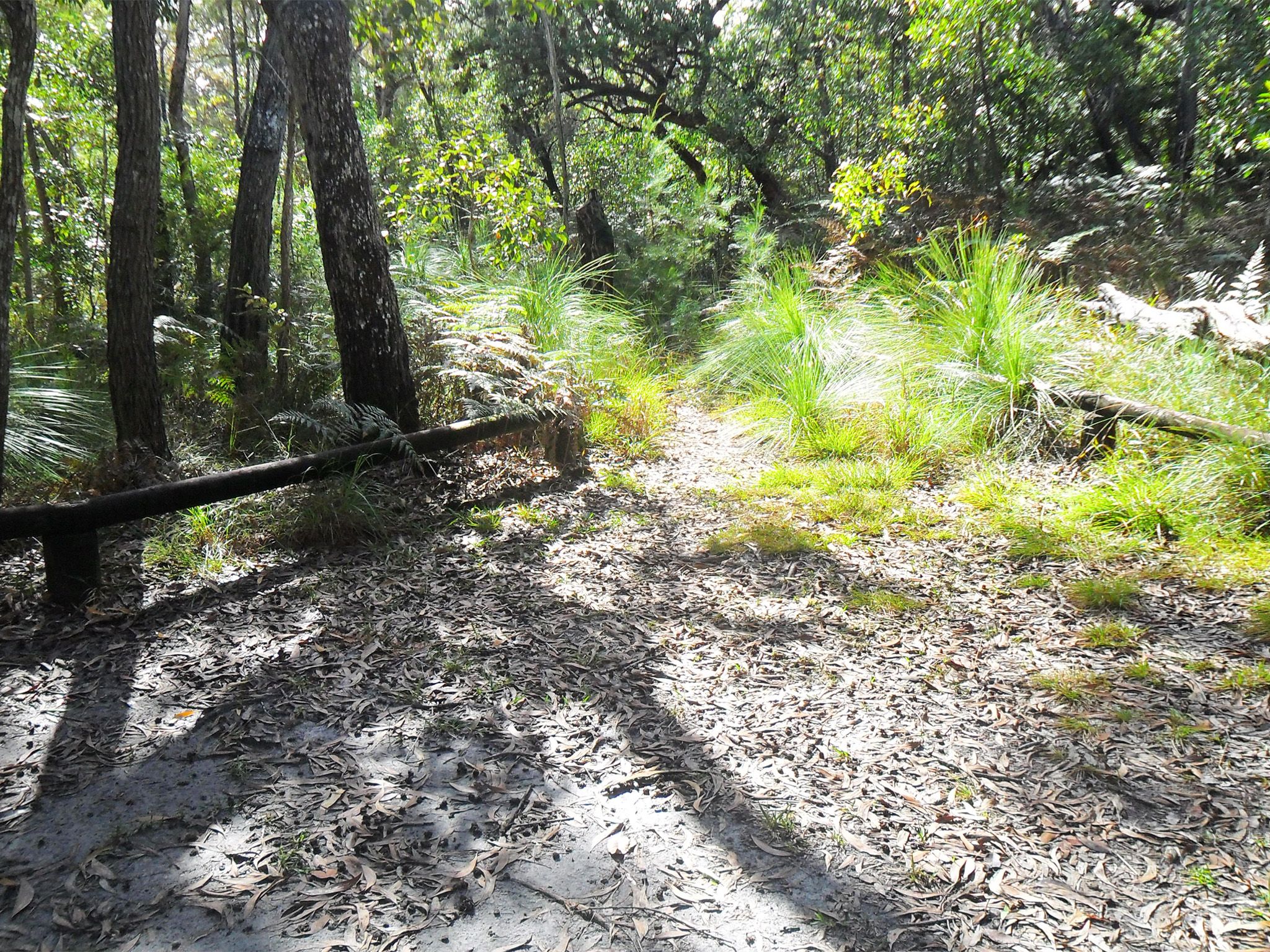
![Upper River camp site 2 is set in forest just 10m back from the water.]() Upper River camp site 2 is set in forest just 10m back from the water.
Photo credit: © Queensland Government
Upper River camp site 2 is set in forest just 10m back from the water.
Photo credit: © Queensland Government
-
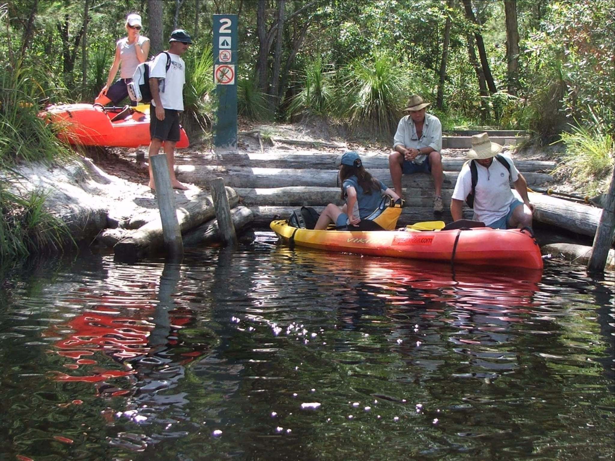
![Dock your canoe or kayak at the canoe landing area and enjoy the pleasant surrounds of this river-side camp site.]() Park your canoe or kayak at the canoe landing area and enjoy the pleasant surrounds of this river-side camp site.
Photo credit: Rob Cameron © Queensland Government
Park your canoe or kayak at the canoe landing area and enjoy the pleasant surrounds of this river-side camp site.
Photo credit: Rob Cameron © Queensland Government
Always check
- Park alerts for the latest information on access, closures and conditions.
- Bureau of Meteorology weather forecasts.
- Current bushfire warnings and incidents and also fire bans and restrictions.
- Your camping permit is booked.
- Any park-specific camping information for
Cooloola Recreation Area.
- Visiting Cooloola Recreation Area safely for important safety information.
Paddle 1.7km upstream from camp site 1, around a north-to-south bend in the river, to reach this peaceful camp site on your exploration of the Upper Noosa River waterway. Jump out at the canoe landing built into the river bank and relax under pink bloodwoods and brush box trees. Enjoy river views from your tent!
Spend the afternoon by the water, spotting birds and other wildlife. If you have a spare day, set off early in the morning, walking 2km along the Camp site 3 walk to (surprise!) camp site 3, then tackle the long but rewarding Cooloola Sandpatch walk.
Getting there and getting around
Upper Noosa River camp site 2 is in Cooloola Recreation Area, Great Sandy National Park, on the Sunshine Coast between Noosa Heads and Rainbow Beach (155–240km north of Brisbane).
- The camp site is in the southern section of Cooloola, in the Upper Noosa River waterway, 12.2km north from Kinaba Visitor Information Centre.
- Canoeists and boaties can access the camp site via Kinaba from Boreen Point and Elanda Point on Lake Cootharaba.
- Walkers can also access the camping area from Harry's day-use area on the Camp site 3 walk.
Via Kinaba
By canoe
- Launch your canoe at Elanda Point and paddle 4.5km (1hr) to the Kinaba Visitor Information Centre.
- Stay close to the shore line while paddling northwards. Plan to cross Lake Cootharaba early in the morning when conditions are likely to be calm and easy to travel.
- From Kinaba, paddle 1hr 20mins to Harrys camping area then a further 50mins to camp site 2.
- Read water safety for important information about staying safe in and near water and caring for parks.
By boat
- Launch your boat from the Boreen Point boat ramp and follow the lake navigation markers out into deeper water and then head on a north-east trajectory towards the visible Cooloola Sandpatch in the distant landscape.
- When you approach a red navigational marker in the middle of the lake (opposite Elanda Point), turn on a near northerly trajectory to the channel markers through very shallow shoals to the Kinaba Visitor Information Centre. The trip is 7km and 15mins travel time.
- From Kinaba allow 1hr 10mins at 6 knots (and no wash) to travel to camp site 2.
- Read boat and fish with care for tips on boating and fishing safety and caring for parks.
Getting to Boreen Point and Elanda Point
- From Brisbane drive 135km north on the Bruce Highway or the Sunshine Motorway to Tewantin; or from Gympie drive 58km south and east on the Bruce Highway to Tewantin.
- From Tewantin drive 19km west and north via McKinnon Drive and Louis Bazzo Drive to Boreen Point. Turn left onto Lake Flat Road and drive 2km to the Elanda Point access road.
From Harrys Hut
- From Harry's day-use area, paddle across the river to the opposite bank to the start of the Camp site 3 walk.
- Walk 5km to camp site 2.
- Read walk with care for tips on walking safely and walking lightly.
Getting to Harrys Hut
- From Brisbane, drive 135km north on the Bruce Highway or the Sunshine Motorway to Tewantin. Follow McKinnon Drive, Louis Bazzo Drive and Junction Road for about 18km north-west to Cootharaba Road. Turn right and travel about 10km along Cootharaba, Kimmond Creek and Dr Pages roads to the Gympie Kin Kin Road. Turn right and drive 6km, then turn right onto Cooloola Way.
- From Gympie, drive 10km east on Tin Can Bay Road, turn right onto to the Gympie Kin Kin Road and drive about 31km, then turn left onto Cooloola Way.
- Drive 4km then turn right onto Harrys Hut Road 4WD track and drive 10km on this very rough sand track to Harrys day-use area. You need a 4WD for this route.
- Read 4WD with care for important information on 4WD safety and minimal impact driving.
Before you visit
Opening hours
Upper Noosa River camp site 2 is open 24 hours a day. Check-in to your camp after 2pm and check-out by 11am on the day of departure.
Check park alerts for the latest information on access, closures and conditions.
1 site - maximum 8 people.
Upcoming camping area availability
Visiting safely
For more safety information see Visiting Cooloola Recreation Area safely and camp with care.
- Pest control program at Teewah Beach and Freshwater camping areas 13–16 May 2024
- King’s Bore Circuit temporary closure 12 May to 10 June 2024
- Planned Burn - Block 8 24–28 April 2024
- Annual Cooloola Hazard Reduction Burn Program 15 April to 31 August 2024
- Permanent fire prohibition on Teewah Beach 1 April 2021 to 11 October 2024
- Cooloola Wilderness Trail - No pedestrian access across Kin Kin Creek 31 January to 1 July 2024
- Portable toilets mandatory for Teewah Beach camping zones 15 March 2022 to 29 November 2024
- Unstable sand cliffs and dunes along Rainbow and Teewah beaches 4 August 2023 to 30 June 2024
- Marine turtles breeding season 1 November 2023 to 30 April 2024
Conditions report
Cooloola conditions report Updated 17 Apr 2024
Critical information for your safety is included in the conditions report—always check it before you visit.