Upper Noosa River waterway
Journey by canoe, kayak or boat to explore the tranquil upper reaches of the Noosa River, bush camping along the way.
- Journey type
- Canoe/kayak, boat
- Distance
- 27.7km one way A path where the start point is different to the finish point
- Time suggested
- Allow 5hrs paddling time.
- Grade
- Unrated
Accessible by
- Conventional vehicle
Journey facilities
- Picnic tables
- Toilets (non-flush)
- Canoeing and kayaking
- Boating
-
![Enjoy picturesque locations that can only be seen from the water along the Upper Noosa River waterway.]() Enjoy picturesque locations that can only be seen from the water along the Upper Noosa River waterway.
Photo credit: Rob Cameron © Queensland Government
Enjoy picturesque locations that can only be seen from the water along the Upper Noosa River waterway.
Photo credit: Rob Cameron © Queensland Government
-
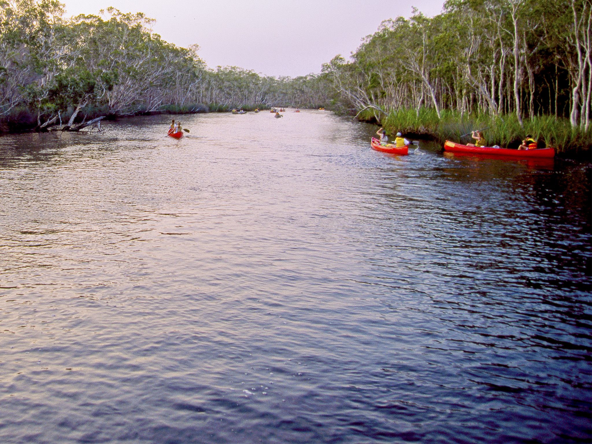
![Embark on the ultimate canoeing adventure and experience the best remote river camping along the Upper Noosa River waterway.]() Embark on the ultimate canoeing adventure and experience the best remote river camping along the Upper Noosa River waterway.
Photo credit: Adam Creed © Queensland Government
Embark on the ultimate canoeing adventure and experience the best remote river camping along the Upper Noosa River waterway.
Photo credit: Adam Creed © Queensland Government
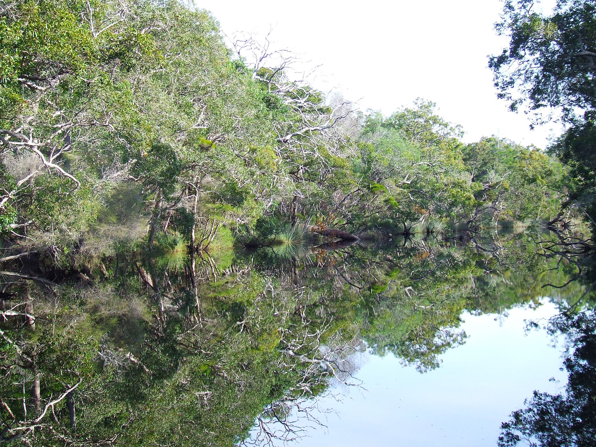
Venture on this renowned journey to experience the upper Noosa River and its wildlife. Launch your craft from Elanda Point and explore the northern edge of Lake Cootharaba, upstream from the Kinaba Visitor Information Centre. Detour to explore Kin Kin Creek or continue to Fig Tree Point camping and day-use areas. Explore the delta lakes of Fig Tree and Como, or continue upriver.
Follow the river as it winds for 2.5km through 'The Narrows', where tannin-stained waters reflect forest and sky, then widens out at Harrys camping and day-use areas. Further upstream, discover remote river camp sites dotted along the river banks. Beyond camp site 3, the only sounds are of nature (and your paddles).
Refer to the Cooloola and Inskip recreation areas discovery guide for a map and more details.
Getting there and getting around
The Upper Noosa River waterway is in Cooloola Recreation Area, Great Sandy National Park, on the Sunshine Coast between Noosa Heads and Rainbow Beach (155–240km north of Brisbane).
- The waterway extends from Lake Cootharaba north into the Noosa River system and can be accessed by canoe from Elanda Point or boat from Boreen Point. Both launching areas are accessible by 2WDs.
- Your route leads across Lake Cootharaba to the Kinaba Visitor Information Centrethen upstream into the narrow channels of the river system, past several camping and day-use areas.
- It's not possible to proceed upstream beyond camp site 15.
- Tour boats operate daily from Noosa and Tewantin. Canoes, kayaks and small boats can be hired from private operators at Boreen Point and Elanda Point.
Getting to Elanda Point and Boreen Point
- From Brisbane drive 135km north on the Bruce Highway or the Sunshine Motorway to Tewantin; or from Gympie drive 58km south and east on the Bruce Highway to Tewantin.
- From Tewantin drive 19km west and north via McKinnon Drive and Louis Bazzo Drive to Boreen Point. Turn left onto Lake Flat Road and drive 2km to the Elanda Point access road.
Exploring by canoe
- Follow the short access road to the Elanda Point QPWS car park and launch your canoe.
- Plan to cross Lake Cootharaba early in the morning when conditions are likely to be calm and easy to travel.
- Keep close to the shore line while paddling north to the Kinaba Visitor Information Centre and entrance to the upper Noosa River.
- Read water safety for important information about staying safe in and near water and caring for parks.
| From–To | Distance | Time |
|---|---|---|
| Elanda Point to Kinaba | 4.5km | 1.5hrs |
| Kinaba to Fig Tree Point | 2km | 20mins |
| Fig Tree Point to Harrys hut | 5km | 1hr |
| Harry's hut to camp site 1 | 3.5km | 35mins |
| Upper Noosa River camp site 1 to camp site 2 | 1.7km | 15mins |
| Upper Noosa River camp site 2 to camp site3 | 2.5km | 30mins |
| Upper Noosa River camp site 3 to camp site 4 | 1km | 10mins |
| Upper Noosa River camp site 4 to camp site 5 | 1km | 10mins |
| Upper Noosa River camp site 5 to camp site 8 | 5km | 1hr |
| Upper Noosa River camp site 8 to camp site 9 | 1km | 10mins |
| Upper Noosa River camp site 9 to camp site 13 | 2km | 20mins |
| Upper Noosa River camp site 13 to camp site 15 | 3km | 30mins |
Exploring by boat
- Launch your boat from the Boreen Point boat ramp and follow the lake navigation markers out into deeper water and then head on a north-east trajectory towards the visible Cooloola Sandpatch in the distant landscape.
- When you approach a red navigational marker in the middle of the lake (opposite Elanda Point), turn on a near northerly trajectory to the channel markers through very shallow shoals to the Kinaba Visitor Information Centre.
- You can take your motor boat on the Upper Noosa River waterway as far as camp site 3. Beyond this point you need a boat with an electric motor.
- Read boat and fish with care for tips on boating and fishing safety and caring for parks.
| From–To | Distance | Time | Speed limit |
|---|---|---|---|
| Boreen Point to Kinaba | 7km | 15mins | 40 knots |
| Kinaba to Fig Tree Point | 2km | 15mins | 6 knots |
| Fig Tree Point to Harrys hut | 5km | 30mins | 6 knots |
| Harrys hut to Upper Noosa River camp site 3 | 7.7km | 45mins | 6 knots |
| Upper Noosa River camp site 3 to camp site 15 | as for canoe | as for canoe | 6 knots |
Wheelchair access
Wheelchair accessible toilets (with assistance) are provided at Fig Tree Point day-use area and Harrys day-use area only.
Drinking water
- Water is provided at Harrys day-use area.
- Treat all water before use.
Before you visit
Opening hours
Upper Noosa River waterway is open 24 hours a day.
Check park alerts for the latest information on access, closures and conditions.
Visiting safely
For more safety information see:
- Pest control program at Teewah Beach and Freshwater camping areas 13–16 May 2024
- King’s Bore Circuit temporary closure 12 May to 10 June 2024
- Annual Cooloola Hazard Reduction Burn Program 15 April to 31 August 2024
- Permanent fire prohibition on Teewah Beach 1 April 2021 to 11 October 2024
- Cooloola Wilderness Trail - No pedestrian access across Kin Kin Creek 31 January to 1 July 2024
- Portable toilets mandatory for Teewah Beach camping zones 15 March 2022 to 29 November 2024
- Unstable sand cliffs and dunes along Rainbow and Teewah beaches 4 August 2023 to 30 June 2024
- Marine turtles breeding season 1 November 2023 to 30 April 2024
Conditions report
Cooloola conditions report Updated 17 Apr 2024
Critical information for your safety is included in the conditions report—always check it before you visit.