Walking

Enjoy panoramic views from the Cooloola sandmass.
Photo credit: Robert Ashdown, Queensland Government

The coastal heath plains put on a spectacular wildflower display in late winter and spring.
Photo credit: Robert Ashdown, Queensland Government
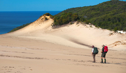
Absorb the open surrounds and views while crossing the Cooloola sandpatch.
Photo credit: Robert Ashdown, Queensland Government

Mist through open eucalypt woodland.
Photo credit: Robert Ashdown, Queensland Government

See southbound migrating humpback whales from July to November from Double Island Point, or look closer inshore for manta rays, dolphins, sharks and marine turtles.
Photo credit: Robert Ashdown, Queensland Government
Walking options
Track classification
The Cooloola Great Walk is a class 4 track according to Australian Standards.
- There are distinct tracks with junctions signposted.
- In remote sections, tracks can become undefined after heavy rain; orange trail markers are present.
- The tracks have a variable track width with very soft sand sections, can be wet under foot at times, and include steep grades and steps.
- Tracks may be overgrown by fast-growing vines; hazards such as fallen trees and branches are likely to be present.
- A moderate level of fitness with previous experience is recommended and ankle-supporting footwear is strongly recommended.
- A moderate level of navigation skills is recommended, involving self-reliance in first aid and the ability to cope with weather hazard situations.
The Cooloola Great Walk has five sections; they are marked, from south to north as S1 to S5. S6 offers a coastal route alternative to S5.
Inland route: S1 (Arthur Harrold Nature Refuge at Noosa North Shore) to S5 (Carlo Sandblow near Rainbow Beach township)—88.1km, allow 5 days walking time.
This track takes you up and over the Cooloola sandmass, across sandblows with views to the horizon over coastal plains and the ocean. You’ll leave the sandmass in places to pass through low heath plains and along the upper Noosa River.
S1 Noosa North Shore track entrance to Brahminy walkers’ camp—17.3km, allow 6hrs walking time.
Start at Arthur Harrold Nature Refuge in Noosa North Shore, an area managed by the Sunshine Coast Regional Council. These low coastal heath plains offer spectacular wildflower displays from late winter to spring.
Shortly after entering the recreation area, you'll ascend the Cooloola sandmass. If you have time, take a side track from the beach to Teewah Landing at Lake Cootharaba (4km return—adds approximately 1hr 30mins to your trip). Another 300m return-climb up Mount Seawah, offers fantastic coastal views.
Make camp early at Brahminy walkers’ camp, in time for sunset—simply stunning!
S2 Brahminy walkers’ camp to Dutgee walkers’ camp—20.3km, allow 7hrs walking time.
Walk over high dunes through scribbly gum Eucalyptus racemosa woodland and blackbutt Eucalyptus pilularis forest. You’ll glimpse Lake Cooloola to the west, and take in the 360° views of sweeping coastal landscapes. You’ll be pleasantly surprised to stumble upon a small patch of shady rainforest along this route.
The one kilometre crossing of the Cooloola Sandpatch will test your navigation skills, but will reward you with awe-inspiring views of the upper Noosa River lakes and hinterland ranges.
The track descends onto heath plains with spectacular wildflowers in winter and spring, and then winds alongside the upper Noosa River to Dutgee walkers’ camp. The site (locally known as Log Landing) is now a protected cultural site; the logs being part of timber cut from the mid 1900s. On calm days, the surface reflections on the river are a perfect mirror image of the surrounding landscape.
Warning! Do not climb on the decaying logs at this camp site. You may suffer serious injury.
S3 Dutgee walkers’ camp to Litoria walkers’ camp—14.8km, allow 5hrs 30mins walking time.
As you leave the upper Noosa River, look back across the heath plains to the sandy finger-like extensions of the Cooloola Sandpatch rolling down the distant sand hills.
The track continues through towering timbered country with vibrant open forests of predominantly blackbutt and coastal wattle.
Be prepared! There are steep sections on this leg of the walk.
You may see Ramsay’s Hut, an old timber cutter’s hut and a relic of Cooloola’s past timber industry. The hut was abandoned before the area was declared a national park in 1975. For your safety, stay on the walking track at all times and do not enter the hut area.
S4 Litoria walkers’ camp to Kauri walkers’ camp—20.5 km, allow 7 hrs walking time.
As you continue north, the track emerges at a perched lake—Lake Cooloomera. The mildly acidic water is perfect habitat for the little “acid” frogs Litoria cooloolensis, restricted to these reedy areas in Cooloola and Fraser Island. Be very alert for snakes here—they like the frogs too!
Perched lakes take years to form in depressions in sand dunes. A saucer-shaped, hard pan of organic debris, sand and peat forms a crust and when filled with rain, reeds and water plants start to thrive.
Don’t leave your mark here—enjoy the lake from a distance. Trampling reeds accelerates erosion and destroys this essential frog breeding habitat.
The track continues over some of the highest sections of sandmass, through pockets of the strongly scented, carrol scrub Backhousia myrtifolia, and some littoral rainforest. Kauri walkers’ camp sits on a ridge of rainforest. The gigantic kauri pine Agathis robusta—growing here close to its southern limit—produces 3 kilogram seed cones which fall anytime from November to late December. Never linger too long under kauri pines!
S5 Kauri walkers’ camp to Carlo carpark (direct route)—15.2 km, allow 5 hrs walking time.
Many birds of the rainforest make up the Cooloola chorus, their songs pierced by the whip crack call of eastern whipbirds.
Ahead is Poona Lake—the largest perched lake in Cooloola—over 160m above sea level. A glorious white sandy beach appears when the water level falls below maximum capacity. Although tempting, swimming is not recommended.
The track crosses Carlo Sandblow for 200m. You’ll view Double Island Point to the east, and to the west, Tin Can Bay. Stay clear of sand cliffs at the edges of sandblows—they may crumble and fall away. Do not attempt to reach the beach from the top of Carlo—there is no access! Stay clear of hang-gliders when pilots are landing or taking off.
A 600m stroll through beautiful scribbly gum forest takes you to Carlo carpark—the northern end of Cooloola Great Walk. A side track takes you to the QPWS information centre on Rainbow Beach Road.
Coastal route: S6 (alternative route to S5)
S6 starts at Kauri walkers’ camp, through Freshwater, along Teewah Beach and up to Double Island Point—a rocky headland, with great views and a lighthouse. Continue north past coloured sand cliffs, finishing at Carlo Sandblow. Rainbow Beach township is 1.2km (downhill) from the track entrance at the Carlo Sandblow carpark.
S6 Option 1—Kauri walkers’ camp to Carlo carpark via Double Island Point—29.1km, allow 10hrs walking time.
This is a long day’s walk along Teewah Beach and up to Double Island Point. Walking S6 instead of S5 means an early start and a late finish to the day. Walking on soft sand (necessary at high tide) slows you down and is tiring.
S6 Option 2—Freshwater to Carlo carpark via Double Island Point—24.7km, allow 8hrs 30mins walking time.
Consider camping at Freshwater, and not Kauri, the night before. This will cut 4.4km or about one hour off S6. Decide in advance and ensure your camp site booking reflects where you plan to camp.
The walk along Teewah Beach is in full sun. Starting the walk at dawn offers cooler temperatures, an ocean sunrise and hundreds of shorebird sightings. Although tempting, do not swim in the ocean, as there may be rips and sharks.
The track up to Double Island Point is steep, but on the way up and once at the lighthouse, there are excellent ocean views to the horizon and long sweeping coastal landscapes. You might see migrating humpback whales as they pass here from July to November, manta rays, dolphins, sharks, turtles and schools of fish.
The track crosses Carlo Sandblow for 200m. You’ll view Double Island Point to the east, and to the west, Tin Can Bay. Another 600m stroll, through beautiful scribbly gum forest takes you to Carlo carpark—the northern end of Cooloola Great Walk. The township of Rainbow Beach is 1.2km from here.
Always walk safely on beaches. Be bright, be seen—reflective vests and backpack strips are recommended for beach walkers, especially at dawn, dusk or at night.
Other walks in Cooloola
There are many short and long walks within the Cooloola Recreation Area, Great Sandy National Park, ranging from short circuits to long hikes and leading to some of the park’s best features.
- Summary of walking tracks in Cooloola Recreation Area.
Make sure you take a copy of the Cooloola Recreation Area and surrounds visitor guide when you walk in other parts of the Cooloola Recreation Area.
Also see: Cooloola Recreation Area webpage.

Be prepared for rain or shine.
Photo credit: Robert Ashdown, Queensland Government

Cooloola's beach is also a road. Be alert to traffic, that usually needs to use the harder sand close to the water's edge.
Photo credit: Robert Ashdown, Queensland Government

Drink plenty of water before setting out then frequently sip water throughout the day. Always drink more water in hot weather.
Photo credit: Robert Ashdown, Queensland Government

Stay on the formed track. Shortcutting leads to erosion.
Photo credit: Robert Ashdown, Queensland Government

When walking across the Cooloola Sandpatch, observe signage and stay within defined areas to minimise your impact. Sandblows scar easily.
Photo credit: Robert Ashdown, Queensland Government

Over thousands of years, weakly cemented sand grains containing iron oxides produced rocky outcrops along giant sand cliffs in Cooloola. For your safety, keep clear of the steep, crumbling cliff edges of Carlo Sandblow.
Photo credit: Robert Ashdown, Queensland Government
Walk safely
Expect the best, but prepare for the worst.
Be aware!
- You are responsible for your own safety.
- Sections of the Cooloola Great Walk are very remote and isolated.
- Accidents have happened, even to experienced bushwalkers.
- Nature can be unpredictable, and a storm, wildfire and flood can happen in a flash.
- Help can be hours away.
- Remote rescues are difficult and expensive.
General safety guidelines
Ensure a safe and enjoyable trip for you and your group.
Be prepared
- Have an emergency plan.
- Ensure experienced adults accompany children.
- Carry maps and compass.
- Carry communication equipment.
Weather checks
- Check weather conditions a day or two before leaving—Australian Bureau of Meteorology.
- Check park alerts for fire danger, track closures and other park news before you leave.
- Walkers’ camps may be closed temporarily in very windy conditions.
- Obey all safety, warning and closure signs.
Consider safety
- Never walk alone. Small groups of about four are ideal.
- Stay on track. The Cooloola Great Walk follows defined walking tracks.
- Do not attempt to walk cross-country or along unauthorised tracks.
- Be especially careful crossing the Cooloola Sandpatch.
- Be surefooted. Wear sturdy, enclosed boots or shoes.
- Don’t overheat—avoid walking in extreme heat or during periods of high fire danger.
- Watch your head!—high winds cause branches to fall.
- Do not push yourselves too hard—know your group and their limitations and change your plans as necessary.
- Keep your group together, especially towards the end of the day.
- Carry enough drinking water, food and a first-aid kit.
- Treat all water before drinking.
- Do not walk at night—plan to set up camp well before sunset.
First aid—be prepared
- At least one person in your party should have an up-to-date first aid qualification.
- Everyone should have a practical working knowledge of basic first aid.
- Carry a well-stocked first aid kit and make sure everyone knows where it is.
- The nearest hospitals are at Gympie and Nambour.
Be familiar with first aid procedures for:
- blisters
- hypothermia
- heat exhaustion
- hyperthermia
- snakebite
- sprained or strained ankles.
Walking conditions
The Cooloola Great Walk is a clearly marked track with a generally firm and stable surface. Some areas are more challenging—steep grades, soft sand and sections of track in full sun. Study the on-screen version of the topographic map and track profile inset and plan your day’s walk accordingly. Natural hazards such as fallen tree limbs, wild animals and wet boggy sections of track may be encountered.
Navigate safely
Purchase a Cooloola Great Walk topographic map, and take a compass and a GPS with you!
Stay on marked tracks and trails. Check your map regularly to mark your progress against features. If you think you are lost, sit down and stay calm. Use your map and compass or GPS. Do not continue travelling until you know where you are.
Be sun-smart
During October to April, plan to cross 'hot' areas (heath plains, sandblows or low lying hollows away from the sea breezes) in the cooler times of day, if possible.
Avoid heat exhaustion!
- Track profiles in the topographic map are designed to help you plan your day’s walking schedule.
- Wear sun protection.
- Take short rests in any shade you might find.
Hydration hint:
- Drink lots of water before setting out.
- Drink water often throughout the day and more in hotter weather.
- Carry a full day’s drinking water every day.
Water safety
Water-related accidents have resulted in serious injuries and fatalities in Cooloola.
- Swimming in lakes, the ocean or the upper Noosa River is not recommended.
- The water bodies in Cooloola are not patrolled by lifeguards.
- Sharks are common in oceans and the river system—deaths have occurred.
- Some rivers, estuaries and open ocean areas contain marine stingers.
Do not dive or jump into water.
- Submerged obstacles and shallow banks are difficult to see.
- Rips—strong undercurrents in the ocean—are common in the waters off Teewah Beach.
Flood safety
Flash floods can occur during and sometimes after heavy rains in the upper Noosa River catchment.
- Flood waters can take days to recede.
- Not every flood is a flash flood.
- Rangers close walking tracks if they have enough prior notice of flooding.
- Check map for flood-prone areas.
Never walk through flooded areas.
- In non-life threatening circumstances—move to the nearest public access road and call a friend or relative to come and get you.
Fire safety
Bushfires can occur without warning.
- Be aware of and prepared for the dangers.
- Be prepared for emergencies.
- Early reporting can avoid disaster.
- Phone Triple Zero (000) to report a bushfire and acts of arson.
- Try 112 in no or low mobile phone reception area.
In a bushfire
- Avoid areas with deep leaf litter.
- Stay low to the ground if it appears less smoky.
- Head towards the nearest Assembly Area (AA)—see topographic map for AAs that may be helpful refuges in wildfires.
Find refuge
If you cannot reach the nearest Assembly Area in time, find refuge as best as you can in areas such as the nearest:
- beach
- road
- firebreak
- waterway
- already-cooled, burnt ground for refuge.
Please note: Not every bushfire is a wildfire. Rangers carry out planned burning to reduce risk of wildfire. In this case, any affected tracks are closed and emergency authorities are notified. Check Park Alerts and the Cooloola Conditions Report .
Headlands and sand cliffs
The rocks around headlands can be slippery and unstable. Large sections of sand cliffs can slip silently.
- Keep well away from cliff edges.
- Always stay on the designated walking track.
- In exposed areas, strong winds may knock you off your feet.
Vehicle traffic
Walkers will encounter traffic along a few inland sections of the Cooloola Great Walk and on beaches. Drivers of 4WD vehicles, some travelling up to speeds of 80km/hr on the beaches, generally prefer to drive on the harder sand near the water. Road rules apply to vehicles on the beach, just the same as they do on the roads.
Stay alert!
- Take note of signs and cross roads with care at designated points.
- Ensure drivers can see you.
- Never walk, sit or lie down in the main traffic areas on the beach.
- Be bright, be seen! Reflective vests and backpack strips are recommended when walking along the beach.
- Look behind you from time to time, as you may not hear approaching vehicles over the sound of wind and surf.
- Expect more traffic at peak periods—public and school holidays.
Strong winds
Trees and branches can break in strong winds. Never linger long or camp under trees in extremely windy conditions.
Keep wildlife wild
The Cooloola Recreation Area is home to an enormous diversity of fauna. Keep in mind that any animals you encounter are wild and should be treated with respect.
- Do not feed any native wildlife, or non-native animals.
- Human food is often harmful.
- Some animals can quickly become reliant on human food and become aggressive.
- Kookaburras, currawongs, brush turkeys, magpies, butcherbirds, wild dogs and goannas are especially vulnerable to scrounging food from you, your backpack or your rubbish container.
- Keep food and rubbish in well-secured containers and hidden in your pack or tent.
- Please take all rubbish out with you.
Also see: the short video clip keep wildlife wild.
Wild dogs
Dingoes and wild feral dogs may be attracted to camp sites for many reasons, but especially by food smells when you’re cooking. You may see them on the walking track or when you sit down to lunch. Although generally shy of humans, keep your distance.
- Never encourage, excite or coax dingoes or wild dogs to come closer.
- Clean up and put food away straight after cooking.
- Leave nothing lying around that can attract dingoes or wild dogs—even toothpaste or dish cloths.
- If threatened, stand to your full height, face the dog, fold your arms across your chest and calmly back away.
- If attacked, defend yourself aggressively.
Also see: Be dingo-safe! web page.
Snakes
Like most of our national parks, Cooloola has a range of snake species. Snakes prefer to avoid humans, so are rarely seen.
If you encounter a snake, calmly walk away without disturbing it.
- Some snakes are more active at night, so always use a torch, wear shoes and watch where you walk.
- Ensure that you are familiar with first-aid for snake bite.
Also see: Queensland Snakes.
Ticks, leeches, mosquitoes and midges
Regularly check yourself for ticks throughout the day and before you go to sleep.
- Carefully remove the whole tick immediately.
- Keep affected clothes away from your other gear.
Leeches can be encountered in rainforests and other wet areas.
- Use salt or heat to remove leeches from skin.
Mosquitoes and midges can be prevalent all year, but especially after periods of rain.
- Carry personal insect protection as some mosquitoes can carry diseases.
In an emergency
Emergencies do happen—so be prepared. What happens if things go wrong depends to a large extent on the planning and preparations you have made at home.
Emergency contact information
Telephone Triple Zero (000) for critical, serious or life-threatening situations.
Be aware
- There is limited mobile phone coverage along the Cooloola Great Walk.
- Try 112 in no or low mobile phone reception areas.
- If this fails, go to the nearest Assembly Area marked as AA on the topographic map or activate your Personal Locator Beacon (PLB).
- Satellite phones can be used on the Cooloola Great Walk.
Use your discretion in non-life threatening situations, but put safety first. If you need to leave the Great Walk track, plan to meet your pick-up vehicle at a public access track, beach point or facility.
Assembly areas
Refer to the Cooloola Great Walk topographic map for a waypoints table which indicates where assembly areas (AA) are located.
Please note:
- Assembly Areas are not 'safe havens' from bushfires, floods, cyclones, tsunami or storms.
- Not every area is an evacuation point.
- In potentially dangerous or emergency situations, Assembly Areas may offer you some protection or at least a place from which you may more easily be located.
- Do not rely on mobile phone coverage at these areas.
- In medical emergencies, seek advice from Triple Zero (000) operators before moving to an Assembly Area.
Help can be hours away
Remote rescues may take a long time, however they may be quicker from defined Assembly Areas as marked on the Cooloola Great Walk topographic map .
Keep in mind:
- You won’t be evacuated in an emergency unless you inform the rescue authorities that you need help.
- Medivac helicopters are available for serious medical emergencies.
- Personal locator beacons (PLBs) help rescuers locate your position.
- If rescuers don’t know your position, two members of your group should move to a nearby clearing and signal the pilot by waving brightly coloured coats or a tent fly.
- One person should always stay with the sick or injured person.
Proper use of a Personal Locator Beacon (PLB)
PLBs should only be used when there is a threat of grave and imminent danger.
- In the event of accidental activation, switch off the PLB.
- Notify the Rescue Coordination Centre Australia as soon as possible by calling 1800 641 792 to ensure a search and rescue operation is not commenced.
Be prepared for disaster
Tsunami, cyclones and extremely high tides can occur along coastal areas. The Noosa River catchment is susceptible to flooding, which cuts off escape routes.
For comprehensive information on preparing for floods, cyclones, tsunami and severe storms, visit Queensland Disaster Management Services.
- Before leaving home, check the Australian Bureau of Meteorology weather forecasts and warnings.
- Tune in to a local radio station for updated warnings and advice.
- Check for up-to-date tsunami warnings; telephone 1300 TSUNAMI (1300 878 6264) or visit www.bom.gov.au/tsunami
- Be aware that an Emergency Alert may be received at any time.
On hearing a tsunami warning…
- Act immediately!—as you may only have minutes to respond.
- Move to higher ground—at least 10m.
- Move further than a kilometre inland from coastal beaches.
Walk softly
Cooloola is a special place that has been loved by generations of visitors. Help to protect the recreation area for future generations by following the guidelines below.
Camping
- Only use existing sites at walkers’ camps.
- Do not dig trenches or flatten or break any vegetation.
- Leave your site in the same or better condition than when you found it, so others can enjoy the Great Walk too.
Leave pets at home
Domestic animals can harm or kill wildlife.
All domestic animals are prohibited in the national park, along the Cooloola Great Walk and all inland areas of the surrounding Cooloola Recreation Area.
Please note: Some domestic animals—horses and dogs—are permitted and may be encountered in designated beach areas around Noosa North Shore and some inland-council managed roads and trails.
Use water wisely
Water is not available at track entrances and is scarce along the track. All walkers’ camps have rainwater tanks. Although regular maintenance checks are done, good water levels cannot be guaranteed. Tank supplies rely on rain. The driest months are August to October.
- Always be water-wise—use only what you need.
- Please turn taps off.
- Report damaged or leaking taps or tanks at your next best opportunity—call 13 QGOV (13 74 68). Mobile phone charges may apply.
Keep waterways clean
All detergents, soaps, sunscreen lotions, insect repellents and toothpastes pollute water and damage aquatic life.
- Please wash yourself and your dishes 100m away from watercourses and lakes.
Stop the spread of disease
Soil carried in on camping gear and boots can contain foreign plant pathogens, such as Phytophthora (root rot disease), or some fungal spores which kill frogs.
- Before you leave home, clean your walking boots, especially the grooves on the sole with a hard brush.
- Clean camping spade and camping gear with a disinfectant wash.
- Brush soil and plant materials out of your tent before each pack up.
- Stay on the tracks.
- Be frog friendly—never handle frogs, their eggs or tadpoles.
For more information watch the weeds, animals and pathogens web clip.
Your rubbish, your responsibility: pack it in, pack it out
Bins are not provided. All rubbish (including food scraps and bagged sanitary products) must be carried out.
- Leave excess packaging at home.
- Use sealable containers to secure food from wildlife.
- Carry enough strong sealable rubbish bags or containers for your entire trip.
You can help the park by bringing out any other rubbish you find. Carry a small rubbish bag, so that even tiny scraps of tin foil, lolly wrappers, and cigarette butts can be removed.
Also see: A short video clip: reduce and recycle.
Open campfires are prohibited
Campfires increase the danger of wildfires. Collecting kindling or firewood is prohibited as it often leads to vegetation being trampled. Fallen plant materials provide shelter for fauna and food for insects and microlife—all forming a food web that keeps the forest healthy.
To reduce the risk of harm to your group and the environment:
- Never leave lit fuel stoves unattended.
- Supervise children when cooking on fuel stoves.
- Test fuel stoves before leaving home.
- Never use fuel stoves in confined spaces such as tents.
- Use non-toxic manufactured fuels only—not wood-based fuels.
Fuel stoves should be used off the ground—minimum recommended height is 20cm. Take care to ensure ash or embers do not burn or singe ground vegetation.
Toilets
Toilets are provided at:
- each of the Cooloola Great Walk walkers’ camp
- Freshwater camping area
- Freshwater day-use area
- Double Island Point.
To assist the treatment process in the toilet systems:
- Do not throw rubbish or sanitary items into toilets.
- Please close the lid after use.
Toilets are not provided between camp sites along the Great Walk.
- Bring a human waste disposal kit to take your waste out with you.
- Kits are available from camping stores or online sales outlets.
- Follow manufacturer’s directions on the packet and dispose of waste responsibly.
If bush toileting is absolutely necessary:
- Bury all faecal waste and toilet paper in holes 45cm deep and at least 100m from watercourses, camps and tracks.
- Cover your waste and the toilet paper with soil or sand.
Also see: Bush toileting practices for some short video clips
- Pest control program at Teewah Beach and Freshwater camping areas 13–16 May 2024
- King’s Bore Circuit temporary closure 12 May to 10 June 2024
- Cooloola Wilderness Trail - No pedestrian access across Kin Kin Creek 31 January to 1 July 2024
Conditions report
Cooloola conditions report Updated 17 Apr 2024
Critical information for your safety is included in the conditions report—always check it before you visit.