Things to do

Enjoy the Butterfly walk, which is wheelchair-accessible (with assistance) at Tully Gorge camping area.
Photo credit: Audrey Reilly © Queensland Government
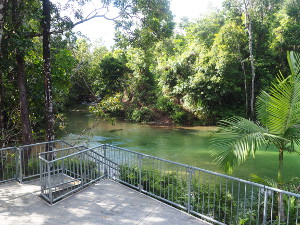
A platform and steps provides access to the rainforest stream at Alligators Nest.
Photo credit: Audrey Reilly © Queensland Government
Camping and accommodation
Camping
Two camping areas are located within the park—Tully Gorge camping area and Cochable Creek camping area. There is no camping at Alligators Nest day-use area.
Camping permits are required and fees apply. Your booking number must be displayed at your camp site.
- Find out more about camping in Tully Gorge National Park.
Other accommodation
A range of accommodation—including hotels, motels, caravan parks, bed and breakfasts, and hostels—is provided at Mission Beach, Tully and Cardwell. For more information, see the tourism information links.
Walking
Maps
Butterfly walk (Grade: easy)
Distance: 375m return
Time: allow 15min walking time
Details: The butterfly walk is located on the southern side of the Tully Gorge camping area, see Tully Gorge camping and day-use areas map . You can start the circuit from either direction. This walk is wheelchair-accessible (with assistance) and takes visitors through tropical rainforest. The area is noted for its butterflies, which are best seen between September and February.
Mount Tyson walking track (Grade: difficult)
Distance: 6.2km return
Time: allow 5hr walking time
Details: The Mount Tyson walking track should only be undertaken by fit and experienced walkers. Do not walk alone and notify a responsible person of your expected time of return before you leave. Please note that the dense rainforest canopy makes it difficult to see the track late in the day, especially when there is cloud cover. Allow plenty of time to return in full daylight.
Heavy rainfall events in this steep terrain regularly wash away the track, making it difficult to follow. People have been lost trying to follow this track. Use of the available track file on a GPS or mobile device is recommended and can be downloaded from the Queensland Government data portal. Mobile coverage in the area is good.
From the council reserve at the end of Brannigan Street in Tully, climb this very steep and challenging track to the 674m summit of Mount Tyson (see Mount Tyson walking track map ). Steep drop-offs occur at many of the boulder vantage points along the track and extreme caution should be exercised. The best view is seen from Scouts Rock lookout at 561m elevation, where you can see the Tully township, Mount Mackay and the coastline including Dunk and Hinchinbrook Islands. Once you reach the summit, be careful of steep drop-offs from the boulders. Enjoy the beautiful colours of the surrounding vegetation and lichen-covered boulders.
Misty Mountain wilderness tracks
Part of the Misty Mountains wilderness tracks network is in Tully Gorge National Park. This 130km network of short and long tracks offers walkers an opportunity to explore an area bounded by Tully, Innisfail, Mena Creek, Millaa Millaa and Ravenshoe.
Trail-bike riding and four-wheel driving
Vehicles are only permitted on gazetted roads—they are not permitted off-road, including on walking tracks and boardwalks. Riders and drivers must be licensed, and trail-bikes and vehicles must be registered. Expect to share the roads with pedestrians, cyclists and other vehicles.
For more information, see trail-bike riding and four-wheel driving.
Picnic and day-use areas
Tully Gorge day-use area
This large, open grassed area has picnic tables and toilets. Do not swim in the nearby Tully River as estuarine crocodiles occur in this section of the river. Additionally, water released from the dam upstream can cause river levels to rise rapidly, and without warning.
Alligators Nest day-use area
This large, grassy area beside the creek has a swimming platform, picnic tables, toilets and a gas barbecue shelter shed. This popular swimming spot was not named after reptiles of any sort, but the local scout group ‘The Alligators’ that used to meet there.
Cardstone weir lookout
Enjoy a quiet rest at this pretty lookout. A fig tree growing over a massive boulder shades a cosy seat on the keyhole viewing deck. Please stay on the boardwalk as the rocks are slippery.
Fishing
Fishing is permitted in the Tully River. Fisheries regulations apply—information on bag and size limits, restricted species and seasonal closures is available from Fisheries Queensland.
Swimming
Alligators Nest is a great spot for a refreshing swim. A large swimming platform provides easy access to the crystal clear waters of this rainforest stream. Never jump or dive into the water and be careful at the water’s edge as rocks may be slippery. Please note that this area is a glass-free zone.
Do not swim in the Tully River at the Tully Gorge camping and day-use areas as estuarine crocodiles occur in this section of the river. Additionally, water released from the dam upstream can cause river levels to rise rapidly, and without warning.